 |
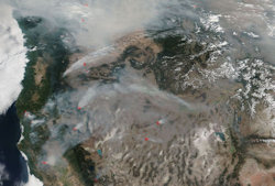
| An Aug. 20, 2018 satellite image showing the West Coast shrouded in smoke from 110 large fires that erupted across the region, burning nearly 2 million acres. Image: NASA. |
Top Wildfire Stories From SEJournal
Updated February 2024
TipSheets
- Wildfire Smoke — Now a Local Story in Unaccustomed Places
- How Much Longer Will Insurers Cover Wildfire Loss Near You?
- Wildland-Urban Interface — How Disastrous Wildfires Get Into Your Neighborhood
- Where There’s Smoke, There's ... a Health Threat
- With Wildfire, When Is Climate Change the Spark?
- Wildfire Season Comes Earlier, Bringing Broader Stories
Toolboxes
- Top Data Sources Can Help Cover the Larger Wildfire Story
- ‘Orange’ Is the New Data — for Wildfire Smoke
- Air Quality Monitors — and Their Data — Now Easy To Find Via Online Map
- Forest Service Offers Mapping Database on Potential Wildfire Hazards
- Tracking Respiratory Health Risks From Wildfire Smoke
- Start Tracking Wildfires Before Things Get Hot
Feature
WatchDog
Inside Story
EJ InSight & More
- U.S. Wildfire Response Badly Off-Base, New Doc Convincingly Shows
- Walking With the ‘Guardians of the Forest’ — Lessons From Coverage of Amazonian Fires
- F/8, N95 and Be There — Wildfire Photojournalism in the Pandemic Era
- Forged in Fire — Author Follows the Flames, and Fights Them, To Cover the Changing Nature of Wildfires
All Wildfire Stories From SEJournal All Wildfire Headlines From EJToday